Trail Walking La Bresse - Rainkopf - Mittlach - Hohneck - Photo

Rainkopf - Mittlach - Hohneck

 tracegps
tracegps

User

© OpenStreetMap contributors
Length
Length
22 km
Max alt
Max alt
1355 m
Uphill gradient
Uphill gradient
1377 m
Km-Effort
Km-Effort  
41 km
Min alt
Min alt
525 m
Downhill gradient
Downhill gradient
1379 m
Boucle
Boucle
Yes
Creation date :
2014-12-10 00:00:00.0
Updated on :
2014-12-10 00:00:00.0

(1 Reviews)

Walking
Walking
8h00
Difficulty : Difficult

Scan this QR Code to open this trail in the SityTrail application

FREE GPS app for hiking

Logo SityTrail SityTrail

IGN / Geographical institutes

Download SityTrail from the App Store Download SityTrail from Google Play

Logo SityTrail SityTrail World

The world is yours!

Download SityTrail from the App Store Download SityTrail from Google Play Download SityTrail on Huawei AppGallery

About

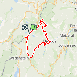
Trail Walking of 22 km to be discovered at Grand Est, Vosges, La Bresse. This trail is proposed by tracegps.

Description

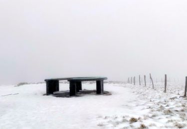
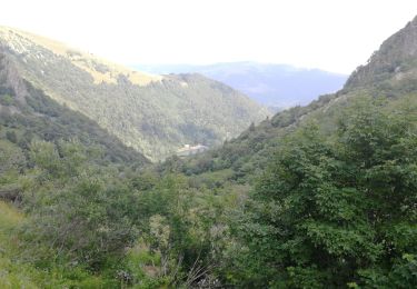
Il est facile de garer sa voiture sur la route des crêtes en contrebas du Rainkopf, mais le départ peut se faire au village de Mittalch, ou même au Hohneck. Depuis le Rainkopf, dirigez-vous vers le sud en direction du Rothenbachkopf (vous pouvez monter au sommet) puis continuez vers le sud, dépassez le Batteriekopf. Au col du Herrenberg, descendre à gauche vers Milltach. A Mittlach, remonter en direction du lac de Schiessrothried (petit détour pour accéder au lac), puis continuez la montée vers les crêtes. Dans cette montée, vous aurez peut-être la chance d'apercevoir des chamois. Arrivés sur la crête, prenez à droite pour monter au Hohneck. Si le temps est clair, vous aurez peut-être une superbe vue sur les Alpes! Retournez ensuite au Rainkopf en passant par le Kastelberg.

Elevation profile

Photos

Positioning

Country:
France
Region :
Grand Est
Department/Province :
Vosges
Municipality :
La Bresse
Location:
Unknown
Start:(Dec)
Start:(UTM)
349780 ; 5319932 (32U) N.

Comments

Please log in to post a review or rate the element


Magnifique parcours fait version trail. .terrains très variés. ..immersion complète dans la nature. ..fin de montée finale très raide avec beaucoup de passage en mode 4 pattes. ..une solide expérience emmagasinée


Trails nearby

Trail Walking La Bresse - 2023-04-16 Marche Abri Lac de Blanchemer vers Lac de Lispach - Photo
Walking
GUIDE
holtzv

Walking

Very difficult
(1)
La Bresse, Grand Est, Vosges, France
23 km | 36 km-effort
8h 4min
No
Trail Walking La Bresse - 2023-04-15 Marche Abri Collet de Etang vers Abri Lac de Blanchemer - Photo
Walking
GUIDE
holtzv

Walking

Medium
(1)
La Bresse, Grand Est, Vosges, France
22 km | 35 km-effort
7h 51min
No
Trail Walking Wildenstein - 2022-02-20 Marche Kruth Grand Ventron - Photo
Walking
GUIDE
holtzv

Walking

Very difficult
(1)
Wildenstein, Grand Est, Haut-Rhin, France
16.8 km | 27 km-effort
4h 52min
Yes
Trail Walking La Bresse - Lac de Lispach et sentier Dielaine  - Photo
Walking
zazie

Walking

Medium
(1)
La Bresse, Grand Est, Vosges, France
9.7 km | 14.9 km-effort
2h 30min
Yes
Trail Walking La Bresse - Kastelberg des pierres, des lacs, des panoramas magnifiques  - Photo
Walking
Alfredy

Walking

Difficult
(1)
La Bresse, Grand Est, Vosges, France
15.1 km | 26 km-effort
6h 11min
Yes
Trail Walking La Bresse - Les 5 lacs autour du Hohneck - Photo
Walking
tiene

Walking

Very difficult
(1)
La Bresse, Grand Est, Vosges, France
21 km | 36 km-effort
7h 21min
Yes
Trail Walking Wildenstein - Col du Bramont - Machey - Blanchemer - Photo
Walking
VacheKiri67

Walking

Medium
(1)
Wildenstein, Grand Est, Haut-Rhin, France
15.3 km | 22 km-effort
4h 27min
Yes
Trail Walking La Bresse - lac de Lispach - Photo
Walking
fedinois1

Walking

Easy
(1)
La Bresse, Grand Est, Vosges, France
10.4 km | 14.1 km-effort
4h 6min
Yes
Trail Walking La Bresse - lac de Lispach - Photo
Walking
fedinois1

Walking

Easy
(3)
La Bresse, Grand Est, Vosges, France
10.4 km | 14.1 km-effort
4h 6min
Yes


Close
My subscriptions